Þingvellir National Park
Walk directly between two tectonic plates at the historic Almannagjá Gorge, a UNESCO World Heritage site with fully paved parking areas.
Iceland’s Ring Road (Route 1) passes some of the most dramatic landscapes on earth. This guide covers the best scenic stops and must-sees along the route, from the geysers and waterfalls of the Golden Circle to the glacial lagoons of Vatnajökull and the remote villages of the East Fjords, so you know exactly where to stop, what to look for, and what makes each location unmissable. For driving tips, vehicle recommendations, and road condition advice, see Hertz Iceland’s Ring Road driving guide.
The Golden Circle is not on the Ring Road itself — it is a loop departing from Reykjavik that takes most visitors 6–8 hours to complete. For Ring Road travellers, it is universally done on half or one day before heading east, and it contains three of the most visited natural and historical sites in Iceland.
Recommended for summer visits (May–September) on paved roads under fair weather. Ideal for budget-conscious travelers.
Essential for winter (October–April) for snow/ice traction. Strongly advised for families, groups of 4+, or heavy luggage space.
Þingvellir National Park holds extraordinary cultural and geological significance as both the birthplace of Icelandic democracy and a rare geological wonder. Established as the site of Iceland’s first parliament, the Alþingi, in 930 AD, this UNESCO World Heritage Site (designated in 2004) marks where Icelandic chieftains gathered to create laws and settle disputes for over 800 years.
Geologically, Þingvellir sits directly on the Mid-Atlantic Rift, where the North American and Eurasian tectonic plates slowly drift apart — creating a dramatic rift valley you can walk through. The park’s most famous feature, the Silfra fissure, offers one of the world’s most extraordinary dive and snorkel experiences: crystal-clear glacial water flowing between the continents, with underwater visibility exceeding 100 meters.
Whether you’re walking the historic plains where Iceland’s democracy was born or standing in the rift between two continents, Þingvellir delivers a rare combination of deep history and geological drama found nowhere else on Earth.
The Geysir Geothermal Area showcases Iceland’s raw volcanic energy in a landscape that rivals Yellowstone National Park in the United States. While the original Great Geysir (which gave all geysers their name) now erupts only rarely, its neighbor Strokkur steals the show — faithfully launching boiling water 20 to 30 meters (65-100 feet) into the air every 5 to 10 minutes with clockwork reliability.
The surrounding geothermal field is alive with bubbling mud pots, hissing steam vents, and vivid mineral deposits in rust-orange and electric-blue hues, all easily explored via a short boardwalk loop from the parking area. Unlike Yellowstone’s sprawling backcountry, Geysir’s compact layout means you can witness multiple eruptions, photograph the colorful hot springs, and experience the otherworldly smell of sulfur all within a 30-minute walk — making it one of Iceland’s most accessible and family-friendly natural wonders on the Golden Circle route.
Gullfoss — the “Golden Falls” — is one of Iceland’s most powerful and dramatic waterfalls, plunging 32 meters (105 feet) in two magnificent stages into the rugged Gullfossgjúfur canyon. The Hvítá River, fed by Langjökull glacier, first drops 11 meters before taking a breathtaking 21-meter plunge into a narrow crevice flanked by canyon walls that tower up to 70 meters high. In summer, an astounding 140 cubic meters (nearly 5,000 cubic feet) of glacial water thunders over the falls every second, creating a mist that often forms golden rainbows in the sunlight — the source of the waterfall’s name. Viewing platforms bring you close enough to feel the roar and spray, so waterproof layers are essential.
Remarkably, Gullfoss almost didn’t survive: in the early 1900s, foreign investors planned a hydroelectric dam that would have destroyed the falls, but Sigríður Tómasdóttir, daughter of the landowner, fought fiercely to save it — threatening to throw herself into the waterfall if construction proceeded and reportedly making repeated trips to Reykjavík to protest the project. Her determination, aided by her lawyer Sveinn Björnsson (who later became Iceland’s first president), saved Gullfoss, and a memorial plaque at the site honors her as Iceland’s first environmentalist and a pioneer of the country’s conservation movement.
Walk directly between two tectonic plates at the historic Almannagjá Gorge, a UNESCO World Heritage site with fully paved parking areas.
Experience the raw power of Strokkur, which erupts reliably every 5–10 minutes, positioned right next to the free visitor parking facilities.
A magnificent 32-meter double cascade with well-cleared upper and lower viewing platforms, easily accessible from the main paved roads.
The South Coast of Iceland is renowned for its stunning natural attractions. This part of the island features a mix of majestic waterfalls, dramatic beaches, and awe-inspiring glaciers. Each site offers a unique glimpse into the raw beauty of Iceland’s landscape.
A practical choice for the South Coast in late spring and summer when roads are clear and you are staying on the main paved route.
The better option from autumn through winter, or for travelers who want extra stability, luggage room, and confidence in changeable weather.
Seljalandsfoss stands 60 meters (197 feet) tall and offers a rare opportunity to walk behind a waterfall. Its unique path allows you to experience the fall from all sides, creating a magical cascade of water views. The waterfall drops from cliffs that were once Iceland’s ancient coastline, fed by glacial meltwater from Eyjafjallajökull.
Skógafoss is one of Iceland’s largest waterfalls, measuring 60 meters (197 feet) high and 25 meters (82 feet) wide. It’s known for its dramatic drop and misty sprays, often framed by rainbows on sunny days. The nearby Skógar Museum, founded in 1949, provides fascinating insights into Iceland’s cultural heritage with over 18,000 regional artifacts.
Both falls are easily accessible directly from Route 1, making them perfect stops for any Ring Road trip. They’re a testament to Iceland’s reputation for breathtaking waterfalls.
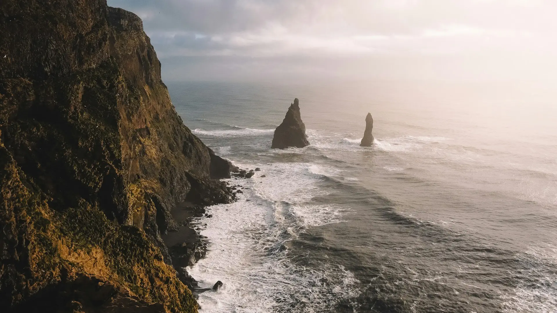
Reynisfjara is famous for its jet-black volcanic sand and striking basalt columns that rise up to 20 meters (65 feet) tall, formed into perfectly hexagonal shapes by cooling lava. It’s a dramatic landscape that feels otherworldly, voted one of the top 10 non-tropical beaches in the world by National Geographic. The beach’s Reynisdrangar sea stacks, rising 66 meters (217 feet) from the Atlantic Ocean, add to its allure — according to Icelandic folklore, these towering formations are trolls turned to stone by the sunrise.
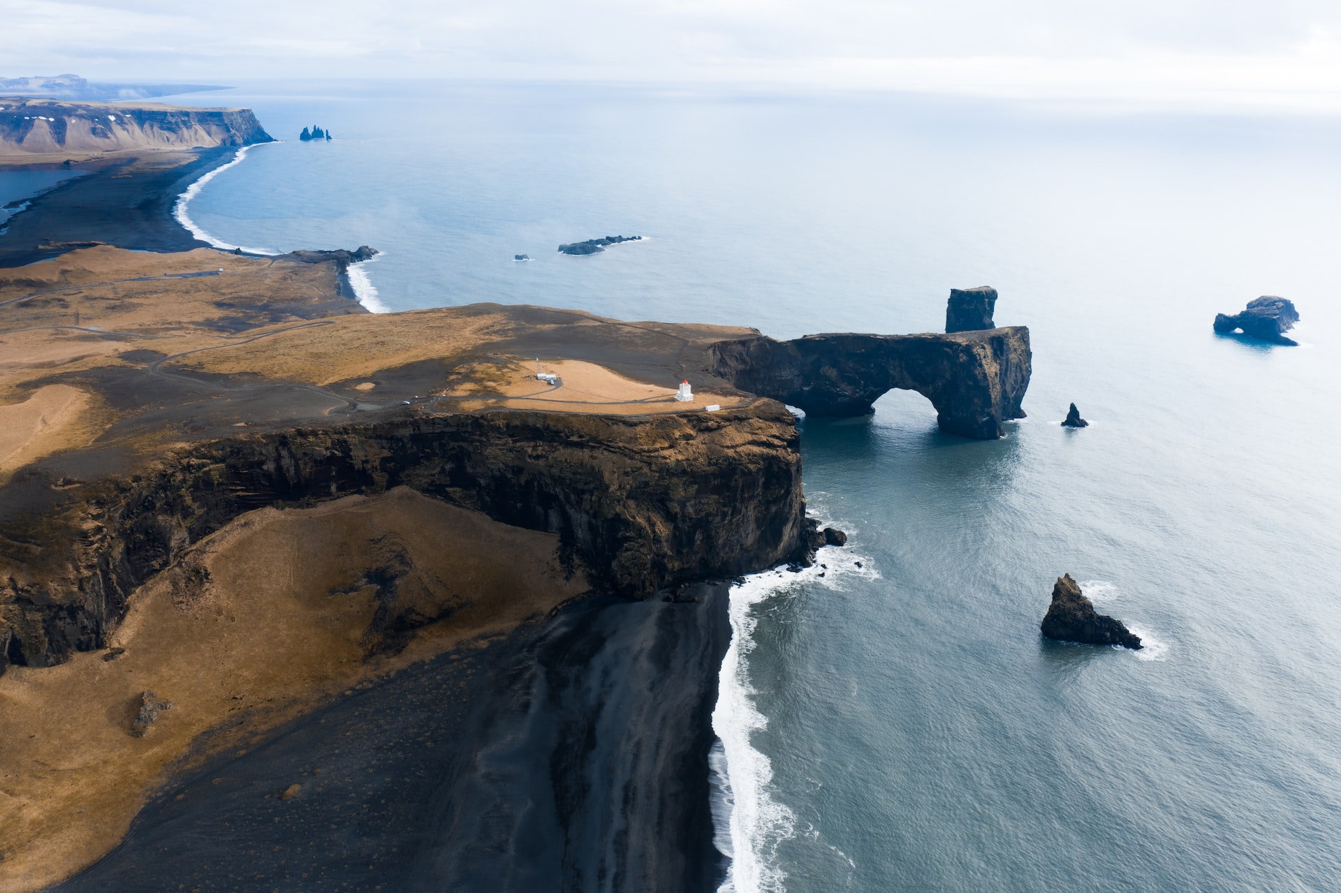
Dyrhólaey is a 120-meter (394-foot) promontory that offers sweeping coastal views and is home to an impressive natural rock arch. It’s a perfect spot for birdwatching, notably puffins from May to August during their nesting season. The promontory features a historic lighthouse and provides one of the best vantage points along Iceland’s south coast, marking the country’s southernmost point.
Both sites are easily accessible with a short detour from Route 1 near the village of Vík. They showcase the unique textures and colors of Iceland’s volcanic coastal scenery — but always respect safety warnings at Reynisfjara, as powerful “sneaker waves” have caused fatalities over the years.
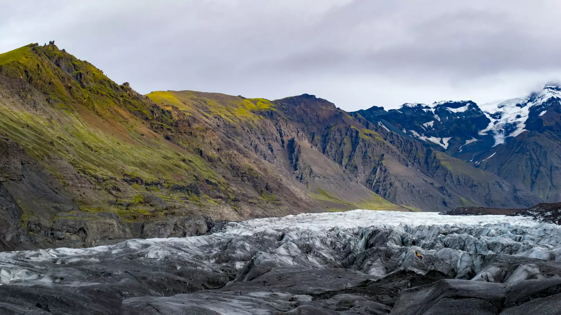
Sólheimajökull Glacier is an adventurer’s paradise and one of Iceland’s most accessible glaciers for guided hikes. This 10-12 kilometer-long outlet glacier descends from Mýrdalsjökull, Iceland’s fourth-largest ice cap, which sits atop the active Katla volcano. Guided glacier tours (available year-round) offer a thrilling experience of navigating through icy crevasses, vivid blue ice formations, and volcanic ash-streaked ice — remnants from Katla’s eruptions. With a certified guide, you can safely explore the glacier’s unique features, including ice caves with mesmerizing deep blue interiors created by compressed ancient ice.
The glacier has been retreating approximately 50 meters per year since the mid-1990s due to climate change, creating a glacial lagoon at its snout that forms during summer months and is filled with stunning icebergs and reflections of surrounding volcanic landscapes. This area is a striking example of Iceland’s dynamic interplay between ice and volcanic activity — markers along the trail poignantly show the glacier’s dramatic retreat over recent decades.
Sólheimajökull is located just off Route 1 (turn onto Road 221), approximately 2.5 hours’ drive from Reykjavík and a short distance from the village of Vík, making it one of the most convenient glacier experiences on the South Coast.
Admire the world-famous black sands and basalt columns. Always stay at least 30 meters back from the shoreline to remain fully safe from dangerous sneaker waves.
Drive up to this magnificent 120-meter promontory for panoramic views of the endless black coastline, volcanic rock arches, and nesting puffins in summer.
An incredible glacier outlet reached easily via Road 221 off Route 1. The walking viewpoint is simple to reach, but glacier walks must only be done with a certified guide.
Vatnajökull National Park is home to Vatnajökull, Europe’s largest glacier by volume, covering approximately 7,700 square kilometers (about 8% of Iceland’s landmass). Established in June 2008, the park spans 14,141 square kilometers (14% of Iceland’s total area), making it Europe’s second-largest national park and a UNESCO World Heritage Site.
The massive ice cap conceals seven active volcanoes beneath its surface, creating a dramatic landscape shaped by the interplay between ice and fire. Visitors encounter majestic glacial tongues, vivid blue ice caves formed by compressed ancient ice (accessible from mid-October to March), and stunning outlet glaciers that descend from the main ice cap.
Sufficient from May to September. All three primary attractions sit directly along the paved Route 1 corridor, meaning standard models handle the loop easily in fair weather.
Strongly recommended from October to April. This southeast segment of Route 1 is highly weather-exposed and prone to severe winter conditions.
Skaftafell Nature Reserve, now part of Vatnajökull National Park, is renowned for its diverse hiking trails and dramatic natural features. Located 326 kilometers (203 miles) from Reykjavík along Route 1, it serves as one of the most accessible gateways to Iceland’s glacial landscapes.
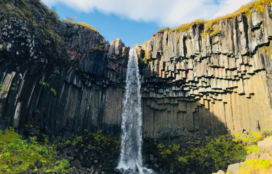
The reserve’s most famous trail leads to Svartifoss Waterfall (“Black Falls”), a 20-meter (66-foot) cascade beautifully framed by striking hexagonal basalt columns that inspired the architecture of Reykjavík’s iconic Hallgrímskirkja church. The hike from Skaftafell Visitor Centre takes approximately 45 minutes (1.9 km one way), passing three smaller waterfalls en route.
Skaftafell also serves as the departure point for guided glacier hikes onto Vatnajökull’s outlet glaciers, offering safe access to explore crevasses, ice formations, and the dynamic glacial environment.
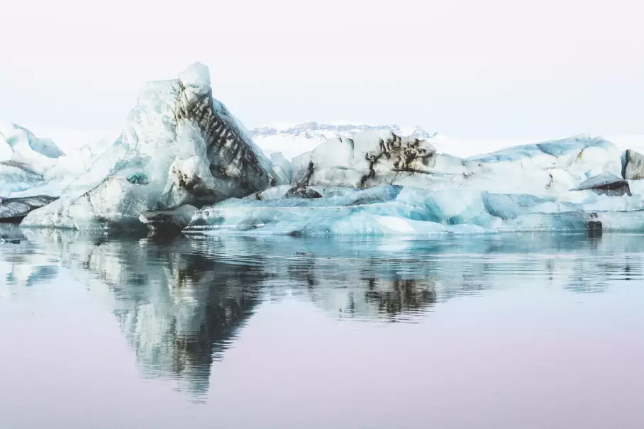
Jökulsárlón Glacier Lagoon is widely considered Iceland’s most spectacular natural wonder — a deep glacial lake (one of Iceland’s deepest) filled with massive icebergs that calve from Breiðamerkurjökull glacier, an outlet tongue of Vatnajökull. Located 380 kilometers (236 miles) east of Reykjavík directly along Route 1, the lagoon is easily accessible with ample parking.
The icebergs display mesmerizing deep blue hues from compressed ancient ice and drift slowly through the lagoon before floating out to the Atlantic Ocean via a short glacial river. Harbor seals frequently swim among the icebergs and can be seen sunbathing on the ice — sightings are common year-round.
Boat tours (amphibian boats and zodiac tours) operate from May to October, offering 45-minute to 1-hour rides that navigate between icebergs for close-up views and seal encounters. Tours depart directly from the Jökulsárlón parking area.
Across Route 1 lies Diamond Beach, where icebergs wash ashore on jet-black volcanic sand, creating one of Iceland’s most photographed landscapes. The contrast between translucent blue ice and dark sand produces an otherworldly scene, especially dramatic at sunrise and sunset.
Hike through the breathtaking trails of Skaftafell to witness Svartifoss, a unique waterfall beautifully framed by dramatic, dark basalt columns.
Marvel at giant blue icebergs floating toward the ocean and look for swimming seals. Allow extra time if joining a guided amphibian or zodiac boat tour.
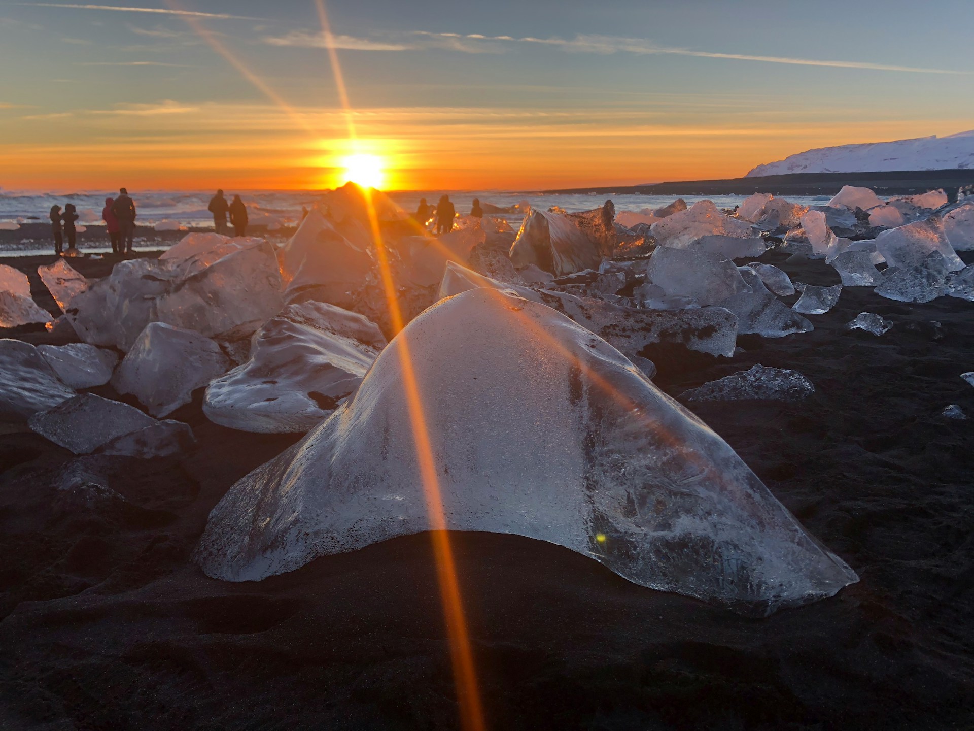
Located directly across Route 1 from the lagoon, where glistening icebergs wash ashore onto pristine black volcanic sand, creating a spectacular view.
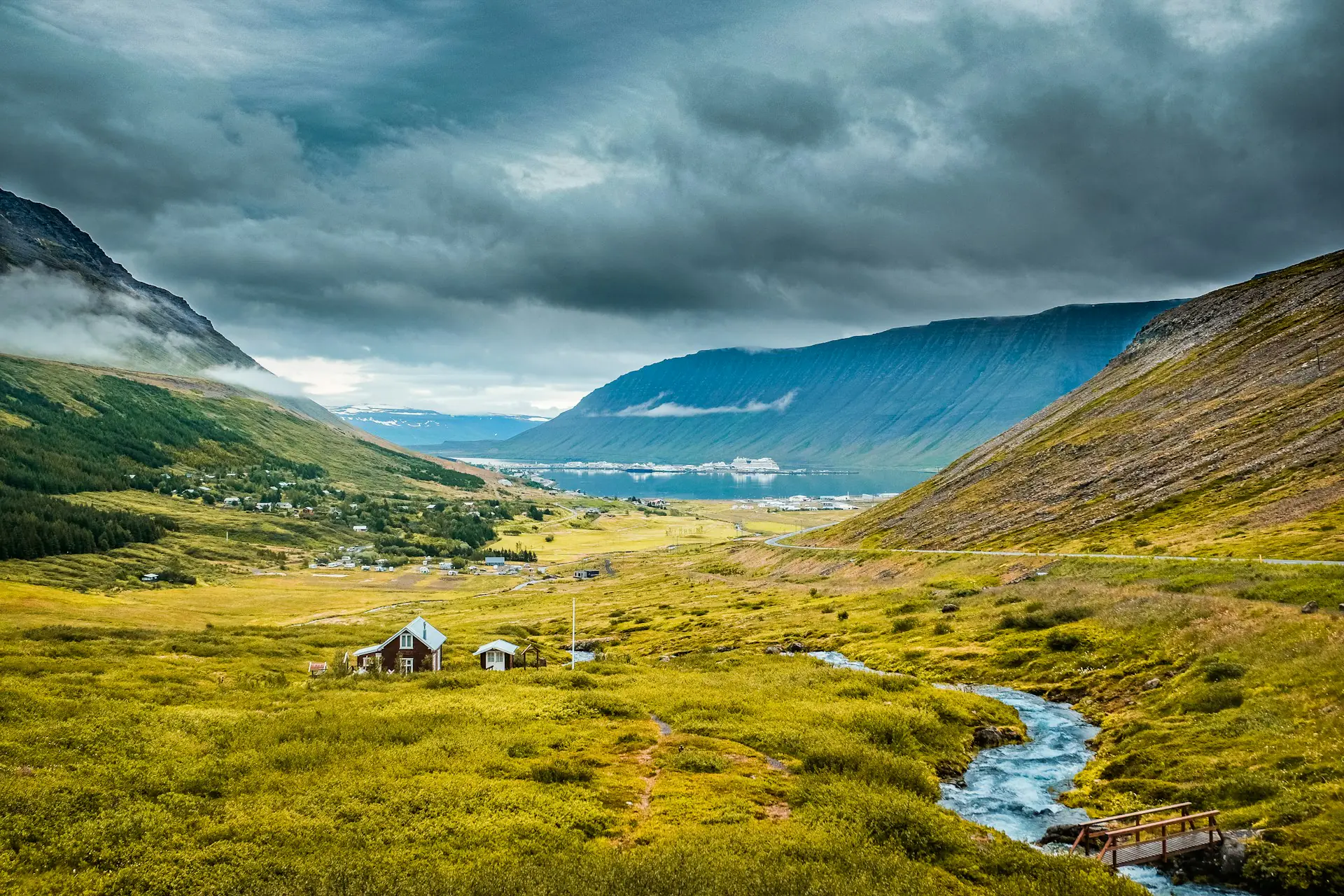
The East Fjords offer a tranquil retreat from Iceland’s more traveled paths, stretching approximately 120 kilometers (75 miles) of dramatic coastline between Berufjörður and Borgarfjörður Eystri. This region captivates with its narrow fjords cutting between towering mountains, picturesque fishing villages, and Iceland’s only wild reindeer population — making it one of the country’s most distinctive and peaceful regions.
The East Fjords are home to Iceland’s entire wild reindeer population of approximately 4,000-7,000 animals, introduced from Norway in the 18th century and now exclusively found in this eastern region. These majestic creatures are most commonly spotted near the Ring Road between Egilsstaðir and Höfn from October to April, when they descend from the highlands to lower elevations.
Mountains meet the sea throughout the East Fjords, creating dramatic coastal vistas where steep peaks rise directly from narrow fjord waters. Travelers navigate winding roads carved into mountainsides that unveil countless natural wonders — dense forests (rare in Iceland), cascading waterfalls, and serene lakes — all while experiencing some of Iceland’s quietest and most remote landscapes.
Standard 2WD models can technically navigate the paved sections to Seyðisfjörður and Hengifoss under optimal summer weather. However, due to narrow, winding fjord roads, upgrading to a compact crossover or mid-size SUV is highly recommended for added control.
Non-negotiable from September to May. Winding mountain passes, steep fjord ascents, and high-probability snow pack mean anything less than an AWD vehicle presents a significant safety risk in the East Iceland territory.
Djúpivogur is a quaint fishing village with a population of around 140 people, offering one of Iceland’s most peaceful harbors and a rich cultural heritage dating back to the 16th century. The village serves as an ideal base for exploring nearby fjords and is known for its Eggin í Gleðivík (“Eggs of Merry Bay”) sculpture installation — 34 oversized eggs representing local bird species, created by artist Sigurður Guðmundsson and installed along the harbor shoreline.
Seyðisfjörður, nestled at the innermost point of its namesake fjord and surrounded by mountains on all sides, is arguably the East Fjords’ most picturesque town with a population of around 676-700 residents. The village is famous for its vibrant wooden houses painted in rainbow colors, charming blue church (Seyðisfjarðarkirkja), and the iconic rainbow-painted street (Tvísöngur) that leads uphill to the church — one of Iceland’s most photographed scenes.
Established in 1895, Seyðisfjörður is located approximately 27 kilometers (17 miles) east of Egilsstaðir along a scenic mountain road (Route 93) and serves as the ferry port connecting Iceland to mainland Europe via the Smyril Line ferry from Denmark. The town boasts a thriving arts scene, galleries, cafes, and the Skaftfell Arts Center, making it a cultural hub in East Iceland.
Hengifoss is Iceland’s third-highest waterfall at 128 meters (420 feet), plunging dramatically over striking red clay layers sandwiched between black basalt rock — creating one of Iceland’s most unique and photogenic geological formations. These distinctive red stripes are clay deposits from ancient interglacial periods, visible evidence of Iceland’s volcanic history spanning millions of years.
The waterfall is located near Lagarfljót lake, approximately 33 kilometers (20 miles) southwest of Egilsstaðir (about 7-8 hours’ drive from Reykjavík). The hike to Hengifoss is 2.5 kilometers (1.6 miles) one way with moderate elevation gain, taking approximately 45 minutes to 1 hour each way, making the total round-trip distance 5 kilometers.
Along the trail, hikers pass Litlanesfoss (also called Stuðlabergsfoss), a smaller but equally captivating waterfall beautifully framed by dramatic hexagonal basalt columns similar to those at Svartifoss. The trail begins from a parking area above Lagarfljót lake and winds steadily uphill through peaceful East Fjords scenery — far quieter than the crowded waterfalls of Iceland’s South Coast.
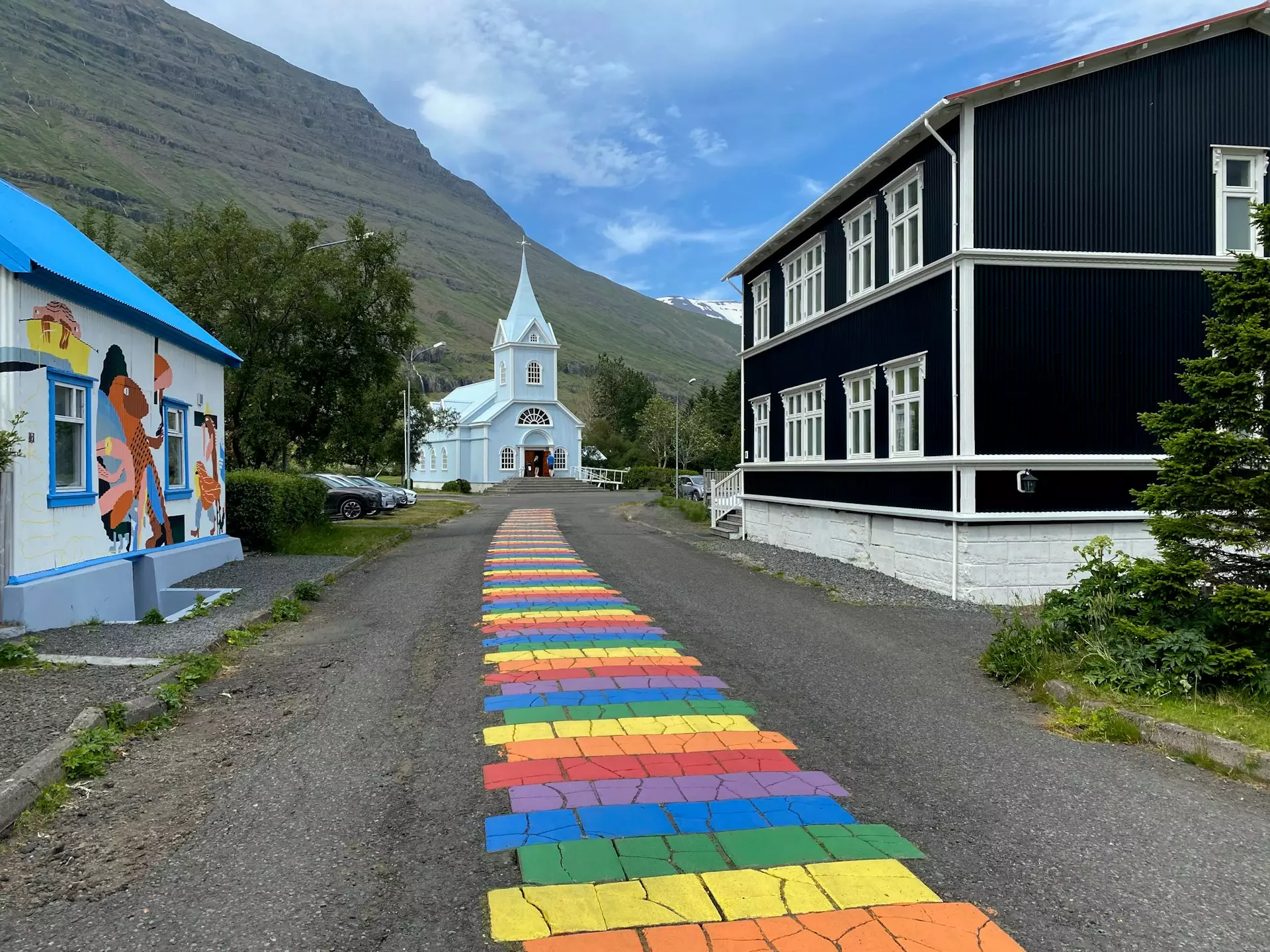
Explore East Iceland’s most picturesque cultural town, famous for its rainbow street and arts scene. Reached via Route 93, a scenic but steep mountain pass.
The primary commercial and logistics lifeline of the region. Ideal for fuel resupply and grocery stops, and home to our convenient Egilsstaðir Airport (EGS) branch.
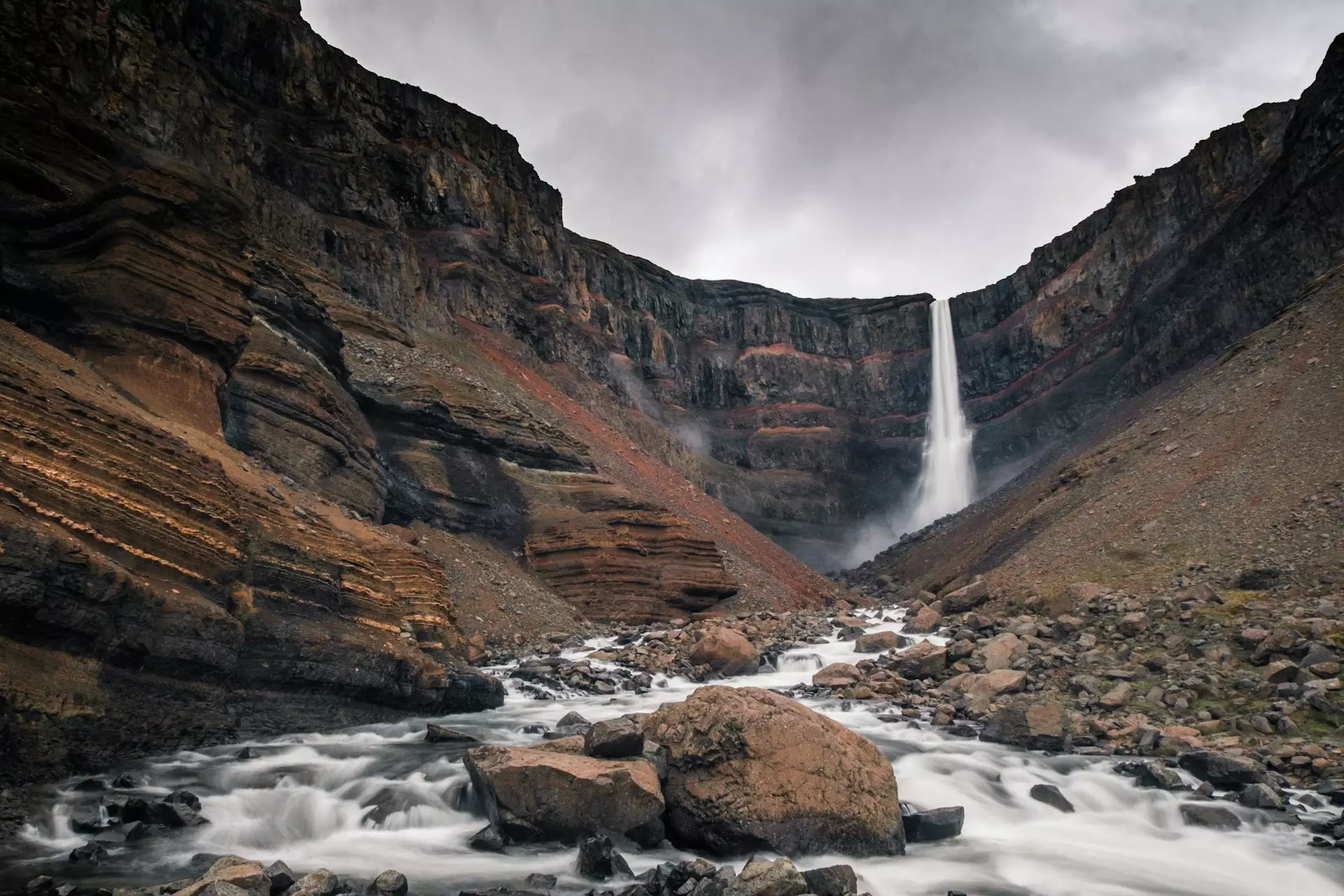
Iceland’s third-highest waterfall, cascading 128 meters down basalt cliffs striped with distinct red clay. Allow 2–3 hours for the round-trip hiking trail.
North Iceland showcases some of the country’s most dramatic geological features and thriving wildlife habitats, making it a highlight of any Ring Road journey. This region offers a unique travel experience where volcanic power meets marine abundance — from Europe’s most powerful waterfall to Iceland’s premier whale-watching destination.
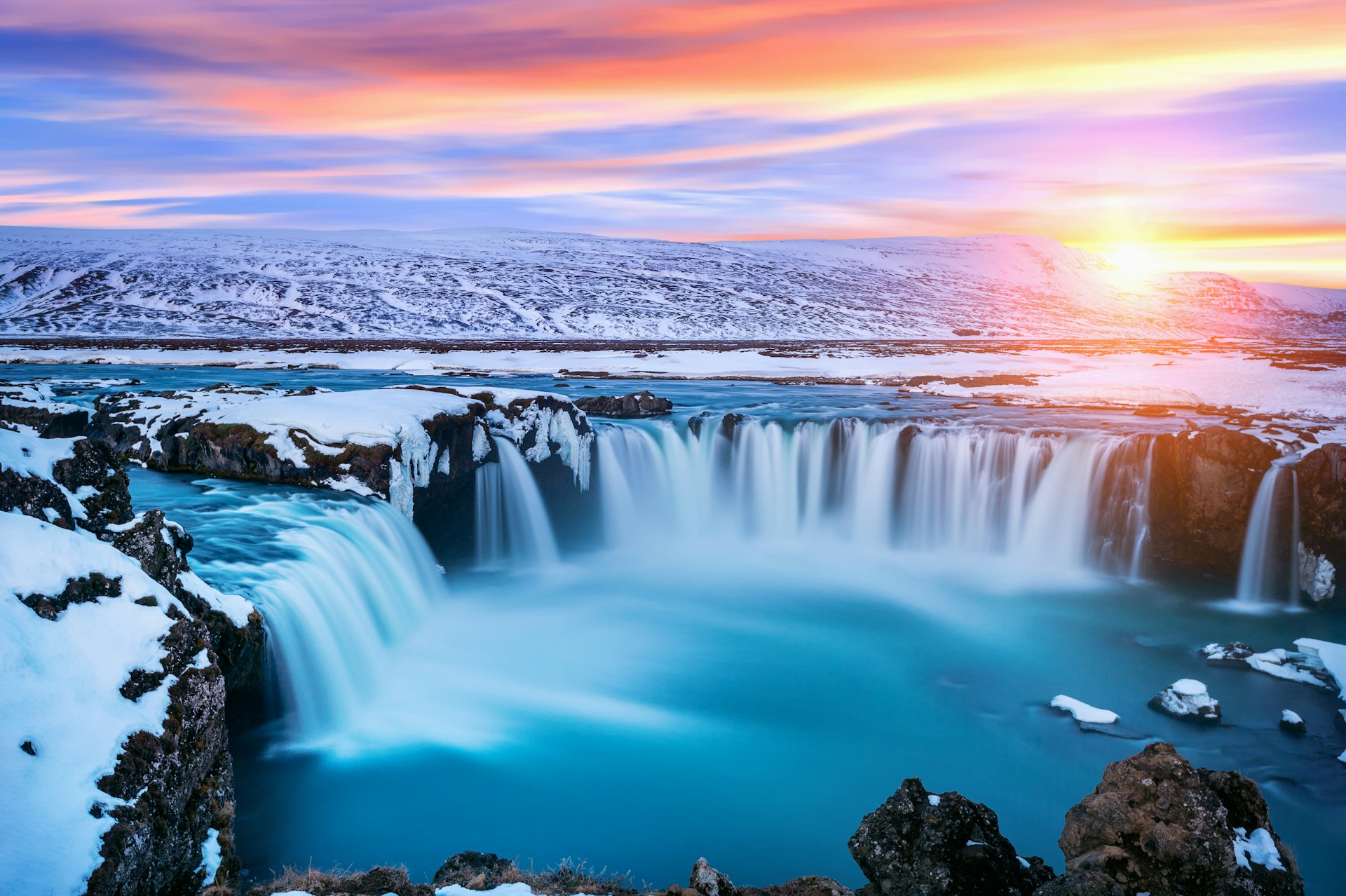
The geothermal area near Lake Mývatn is a must-see, featuring bubbling mud pools, hissing fumaroles, and vibrant hot springs that vividly display Earth’s geothermal energy at work. Dettifoss, with its thunderous roar and massive flow rate, impresses as Europe’s most powerful waterfall, while Goðafoss captivates with its elegant, horseshoe-shaped cascade and historical significance.
Húsavík, the whale-watching capital of Iceland, draws wildlife enthusiasts from around the world with its 97-98% whale sighting success rate. The town itself charms visitors with its colorful harbor, historic buildings, and renowned Húsavík Whale Museum.
Sufficient for navigating paved main veins (Route 1, Route 85, Route 862) between June and August in clear weather. Be advised that gravel offshoots like Krafla (Route 863) will require slow, deliberate driving to protect the chassis.
The optimal choice for Northern Iceland in all seasons. The combination of long highway distances, gravel infrastructure (Krafla, Dettifoss loops), and highly unpredictable northern storm fronts makes an AWD platform the most secure and confident vehicle choice.
Lake Mývatn is a shallow volcanic lake covering approximately 37 square kilometers (14 square miles) in North Iceland’s active volcanic zone, situated near the powerful Krafla volcano. The lake formed around 2,300 years ago during a basaltic lava eruption and has become one of Europe’s premier birdwatching destinations.
The area is renowned for hosting 15-16 breeding duck species — more than anywhere else in Europe — including Barrow’s goldeneye, harlequin duck, and the common scoter, along with over 50 other bird species that nest around the lake and Laxá river. The lake’s name literally means “Midge Lake,” referring to the enormous swarms of non-biting midges (Chironomidae) that emerge each summer and form a crucial part of the ecosystem.
Skútustaðagígar pseudocraters on the lake’s southern shore are among North Iceland’s most fascinating geological features. These rootless volcanic cones formed when molten lava flowed over wetlands approximately 2,300 years ago — steam explosions created the crater-like formations without any volcanic eruption. A short, easy walking trail loops through the craters, offering stunning views over Lake Mývatn.
Hverir geothermal area, located approximately 6 kilometers (4 miles) east of Lake Mývatn along Route 1, boasts bubbling sulfur mud pots, steaming fumaroles, and vividly colored mineral deposits in rust-orange, yellow, and electric-blue hues. The otherworldly landscape sits at high geothermal activity, with temperatures reaching boiling point just beneath the surface — making it one of Iceland’s most accessible and dramatic geothermal sites.
Dettifoss is Europe’s most powerful waterfall, plunging 45 meters (144-150 feet) over a 100-meter (328-foot) wide edge with a thunderous roar that can be heard from a distance. Fed by the glacial Jökulsá á Fjöllum river flowing from Vatnajökull glacier, Dettifoss discharges an astounding average of 193 cubic meters (6,815 cubic feet) of water per second — creating a massive spray cloud visible from both viewing platforms.
Located within Vatnajökull National Park in Northeast Iceland, Dettifoss is accessible via Route 862 (paved, east bank) or Route 864 (gravel, west bank) from the Ring Road (Route 1). The east bank offers the most dramatic views and easier access with paved roads and well-maintained paths to viewing platforms. The waterfall plunges into the dramatic Jökulsárgljúfur Canyon, carved by glacial flooding after the last Ice Age.
Goðafoss (“Waterfall of the Gods”) is a 12-meter (39-foot) tall, horseshoe-shaped cascade approximately 30 meters (98 feet) wide, located directly along Route 1 between Akureyri and Lake Mývatn. The waterfall is steeped in Icelandic history: legend says that in the year 1000 AD, when Iceland officially converted to Christianity, the lawspeaker Þorgeir Ljósvetningagoði threw his pagan idols into this waterfall, giving it its name.
Goðafoss is one of Ring Road’s most accessible waterfalls — parking is free and viewing platforms are just a short 2-3 minute walk from the car park on both sides of the river. The falls are especially popular for Northern Lights photography from September to April, as the horseshoe cascade provides a dramatic foreground for aurora displays.
Húsavík, a charming seaside town with approximately 2,300 residents, is renowned as Iceland’s whale-watching capital and one of the best places in Europe to observe whales in their natural habitat. Located on the shores of Skjálfandi Bay in North Iceland, the town offers whale-watching tours with an impressive 97-98% success rate for overall whale sightings year-round.
The thriving ecosystem in Skjálfandi Bay attracts up to 11 different cetacean species, with humpback whales and minke whales being the most commonly observed from March to November. Peak whale-watching season runs from May to September, when sightings are most reliable and weather conditions are favorable. Other species occasionally spotted include blue whales, orcas (killer whales), white-beaked dolphins, and harbor porpoises.
Whale-watching tours typically last 2.5 to 3 hours and depart multiple times daily from Húsavík’s harbor. The town is also home to the Húsavík Whale Museum, which provides educational exhibits about cetacean biology, conservation, and the history of whaling in Iceland.
Beyond whale watching, Húsavík offers a picturesque harbor lined with colorful wooden houses, excellent seafood restaurants, and the striking wooden Húsavíkurkirkja church overlooking the bay. The town is located approximately 90 kilometers (56 miles) northeast of Akureyri and is easily accessible via Route 85 from the Ring Road.
A magnificent volcanic lake area offering rich birdlife, geological pseudocraters, and soothing geothermal baths directly off the Ring Road artery.
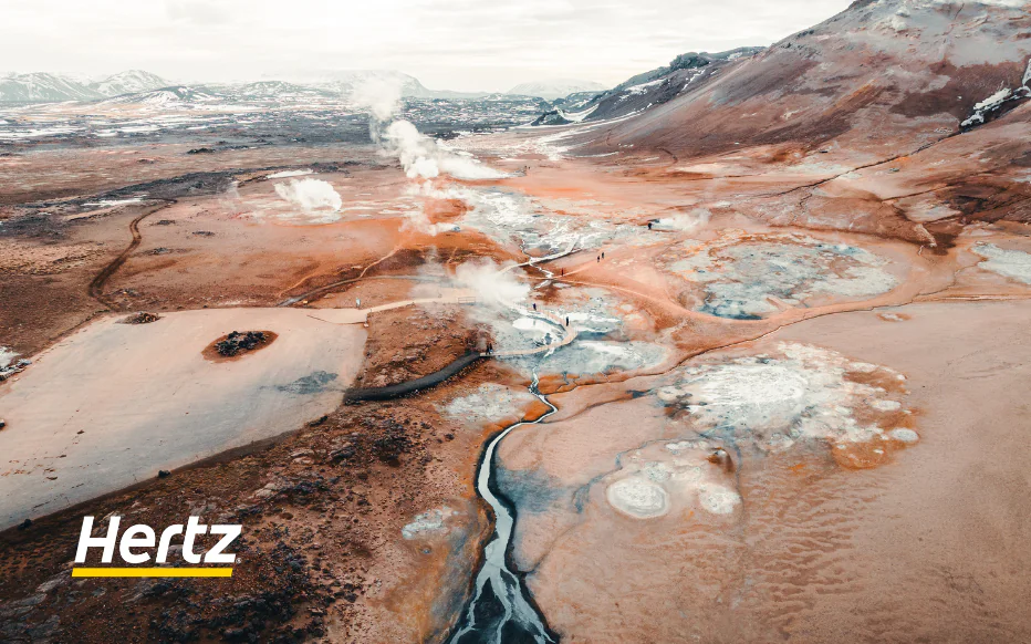
Walk among hissing steam vents and boiling mud ocher pots. Features a highly accessible parking lot equipped with clear sensory warning signage.
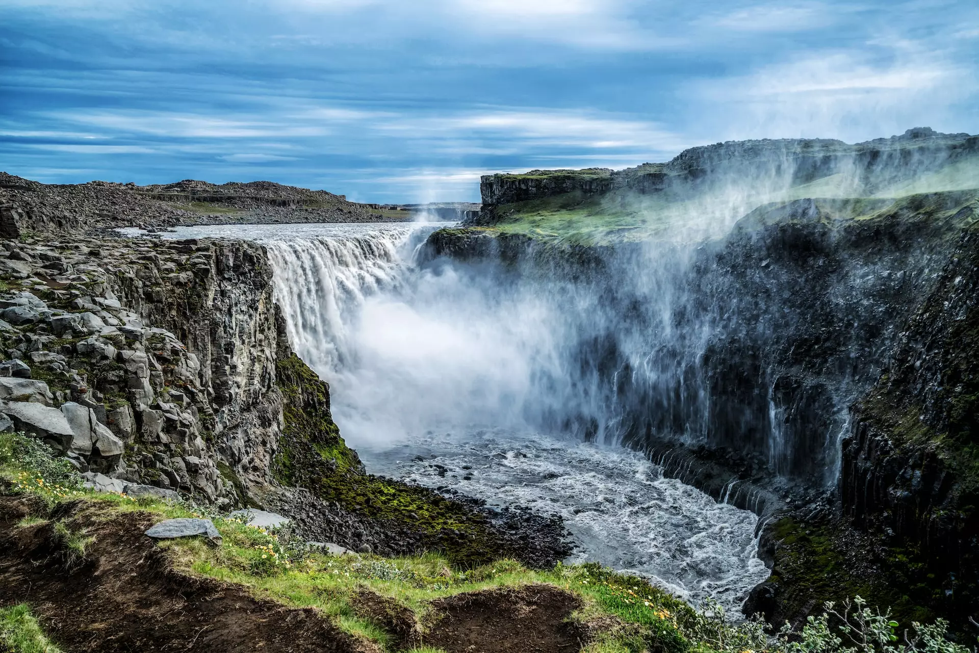
Europe’s most powerful waterfall. Reached via the west bank (paved Route 862) or the east bank (gravel Route 864, requiring maximum driving caution).
The historic “Waterfall of the Gods,” dropping 12 meters in a scenic semi-circle loop. Fully operational with free parking on both the east and west viewing banks.
Akureyri, known as the “Capital of the North,“ is Iceland’s second-largest urban area with a population of approximately 19,500-20,000 residents (2026 estimate). Located at the head of Eyjafjörður fjord (Iceland’s longest fjord), approximately 388 kilometers (241 miles) north of Reykjavík, Akureyri serves as the cultural and economic hub of North Iceland.
The city combines urban amenities with stunning natural surroundings — snow-capped mountains rise dramatically on all sides while the deep fjord waters stretch northward to the Arctic Ocean. Beyond Akureyri, the Tröllaskagi Peninsula (“Troll Peninsula”) offers some of Iceland’s most dramatic coastal scenery, charming fishing villages, and year-round outdoor adventures.
Whether exploring Akureyri’s vibrant cultural scene, relaxing in geothermal pools, or discovering remote coastal villages along the Arctic Coast Way, North Iceland rewards travelers with authentic Icelandic experiences away from the crowds of the South Coast.
Sufficient for Route 82 and all primary paved coastal loops under stable summer conditions. However, because Tröllaskagi coastal sectors feature narrow paths and sharp marine turns, upgrading to a crossover or mid-size SUV ensures noticeably superior stability.
Absolutely non-negotiable from September to May. Navigating coastal blizzards, accessing the Hlíðarfjall ski mountain, and dealing with freezing spray ice on exposed coastal routes like Route 82 require an AWD platform without exception.
Akureyri is a thriving city despite its small population, offering excellent museums, restaurants, shopping, and cultural attractions that rival Reykjavík. The city’s centerpiece is the striking Akureyrarkirkja church, designed by renowned Icelandic architect Guðjón Samúelsson (who also designed Reykjavík’s Hallgrímskirkja) — the modernist church sits prominently on a hill overlooking downtown and is one of Iceland’s most photographed landmarks.
Akureyri Botanical Gardens (Lystigarður Akureyrar) are among the world’s northernmost botanical gardens, located just 50 kilometers (31 miles) south of the Arctic Circle. Established in 1957 within a park created by local women in 1912, the gardens now cover 3.6 hectares and host over 7,000 plant species — approximately 400 native to Iceland and the remainder from around the world. The gardens are free to enter and open year-round, with peak visiting from June 1 to September 30 (daily hours: 8:00-22:00 weekdays, 9:00-22:00 weekends). A café operates during summer months, and the gardens remain a beloved spot for quiet contemplation amid vibrant blooms.
Cultural highlights include the Akureyri Art Museum, the Aviation Museum, and Nonnahús (childhood home of beloved Icelandic children’s author Jón Sveinsson, known as “Nonni”). The city also features Iceland’s iconic heart-shaped traffic lights — a beloved local symbol that has become a quirky Akureyri trademark.
Outdoor enthusiasts can enjoy Hlíðarfjall ski resort (just 10 minutes from downtown), geothermal swimming pools including the renowned Sundlaug Akureyrar, and easy access to whale watching, hiking, and fishing in the surrounding fjord. Akureyri is also a convenient base for exploring Lake Mývatn, Goðafoss, and the entire North Iceland region.
The Tröllaskagi Peninsula (“Troll Peninsula”) is one of Iceland’s most dramatic and rugged regions, characterized by towering mountains, deep valleys, steep cliffs, and picturesque fjords carved by volcanic and glacial activity. Located in North Iceland, Tröllaskagi is easily accessible via the Ring Road and sits approximately 1.5 hours’ drive from Akureyri.
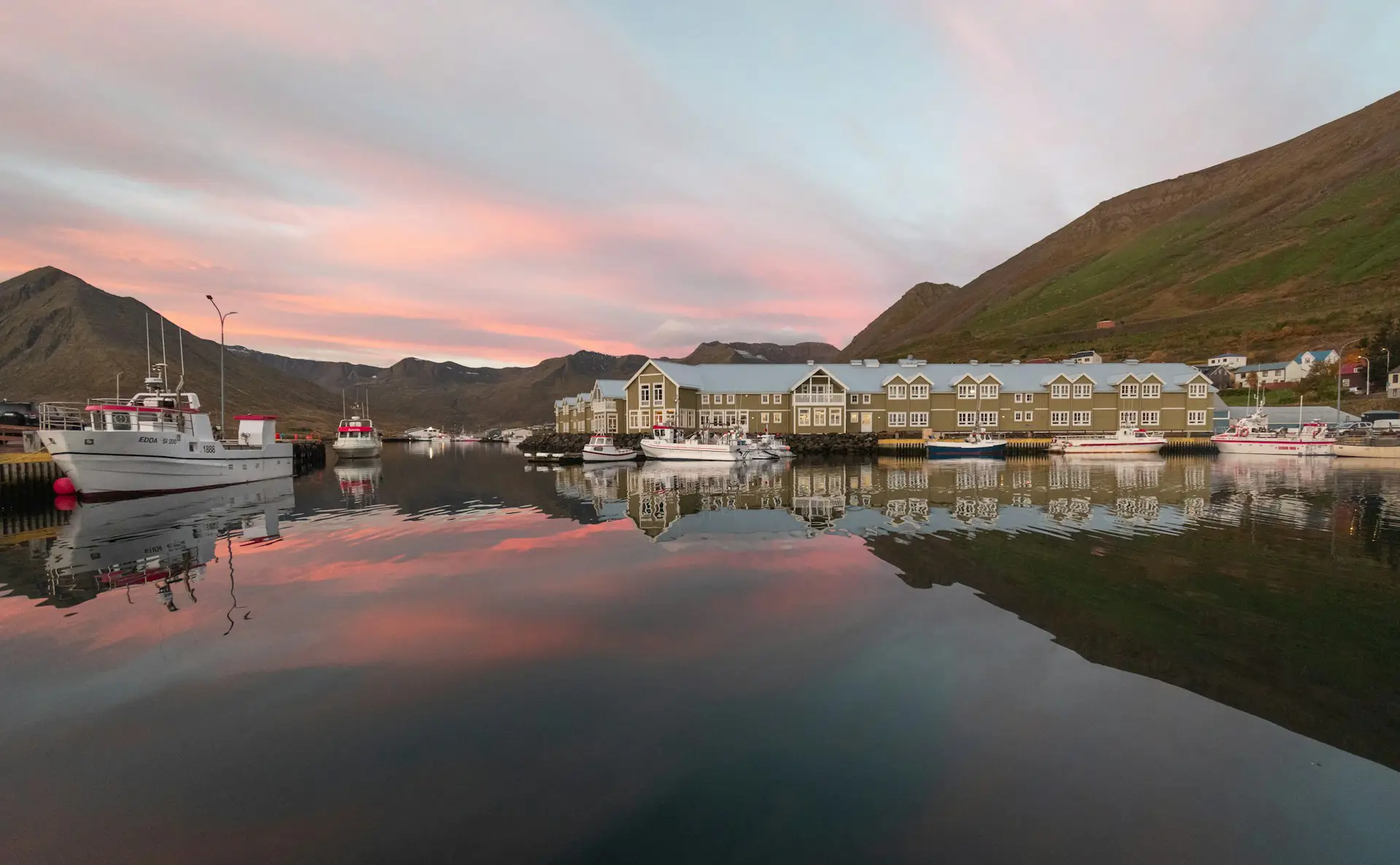
Siglufjörður, the northernmost town in Iceland, was once the “Herring Capital of Iceland” during the early-to-mid 20th century, when up to 3,000 residents (triple the current population of ~1,200) worked in the thriving herring fishing industry. Today, the charming village is renowned for its colorful fishing harbor, stunning fjord setting surrounded by mountains (including Hestskarðsdalur, towering 855 meters above sea level), and the Síldarminjasafnið Herring Museum — Iceland’s largest industrial museum, open May to September. The annual Siglufjörður Herring Festival in August celebrates this heritage with traditional food, music, and culture. The drive to Siglufjörður from Akureyri takes approximately 1 hour 15 minutes via Route 82.
Dalvík, another coastal village on Tröllaskagi, is a popular departure point for whale-watching tours and offers stunning views across Eyjafjörður fjord to the mountains beyond. The village also hosts the annual Fiskidagurinn Mikli (“Great Fish Day”) festival each August, celebrating Iceland’s fishing heritage with free seafood tastings.
Ólafsfjörður and Hofsós are additional charming coastal villages worth exploring for their dramatic fjord settings, local museums, and authentic fishing village atmosphere. Hofsós features the stunning Hofsós Infinity Pool, a geothermal swimming pool perched on a hillside with panoramic views over Skagafjörður fjord.
The Tröllaskagi Peninsula offers year-round outdoor activities including hiking, skiing, whale watching, and scenic drives along the Arctic Coast Way — a 900-kilometer coastal route showcasing North Iceland’s most dramatic landscapes. The region is also renowned for its high population of Icelandic horses, often visible grazing in fields against dramatic mountain backdrops.
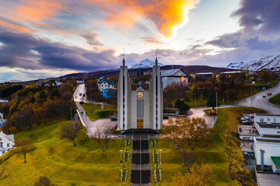
Iceland’s “Capital of the North” and a premium urban hub. Features the iconic modernist Akureyrarkirkja and serves as our core regional airport (AEY) rental branch gateway.
A dramatic coastal fishing village nestled deep within the majestic folds of the Tröllaskagi Peninsula. Reached via the fully paved coastal loops of Route 82.
Iceland’s northernmost town, historic herring capital, and a spectacular fjord harbor destination. It offers exceptional mountain backdrops and free visitor parking throughout.
West Iceland offers two spectacular detours from the Ring Road, each showcasing Iceland’s dramatic landscapes in distinct ways. While neither the Snæfellsnes Peninsula nor the Westfjords are accessible via Route 1, both regions reward adventurous travelers with some of Iceland’s most breathtaking and uncrowded scenery.
Snæfellsnes Peninsula, often called “Iceland in Miniature,” sits approximately 145 kilometers (90 miles) from Reykjavík and is easily accessible year-round via Route 54 from Borgarnes (a turn-off from Route 1). The peninsula stretches 90 kilometers (56 miles) long and packs an astonishing variety of landscapes — glaciers, volcanoes, lava fields, black sand beaches, dramatic coastal cliffs, and charming fishing villages — into one compact area. A full loop around the peninsula covers approximately 200 kilometers (3 hours of pure driving time), though most visitors allocate 1-2 days to explore properly.
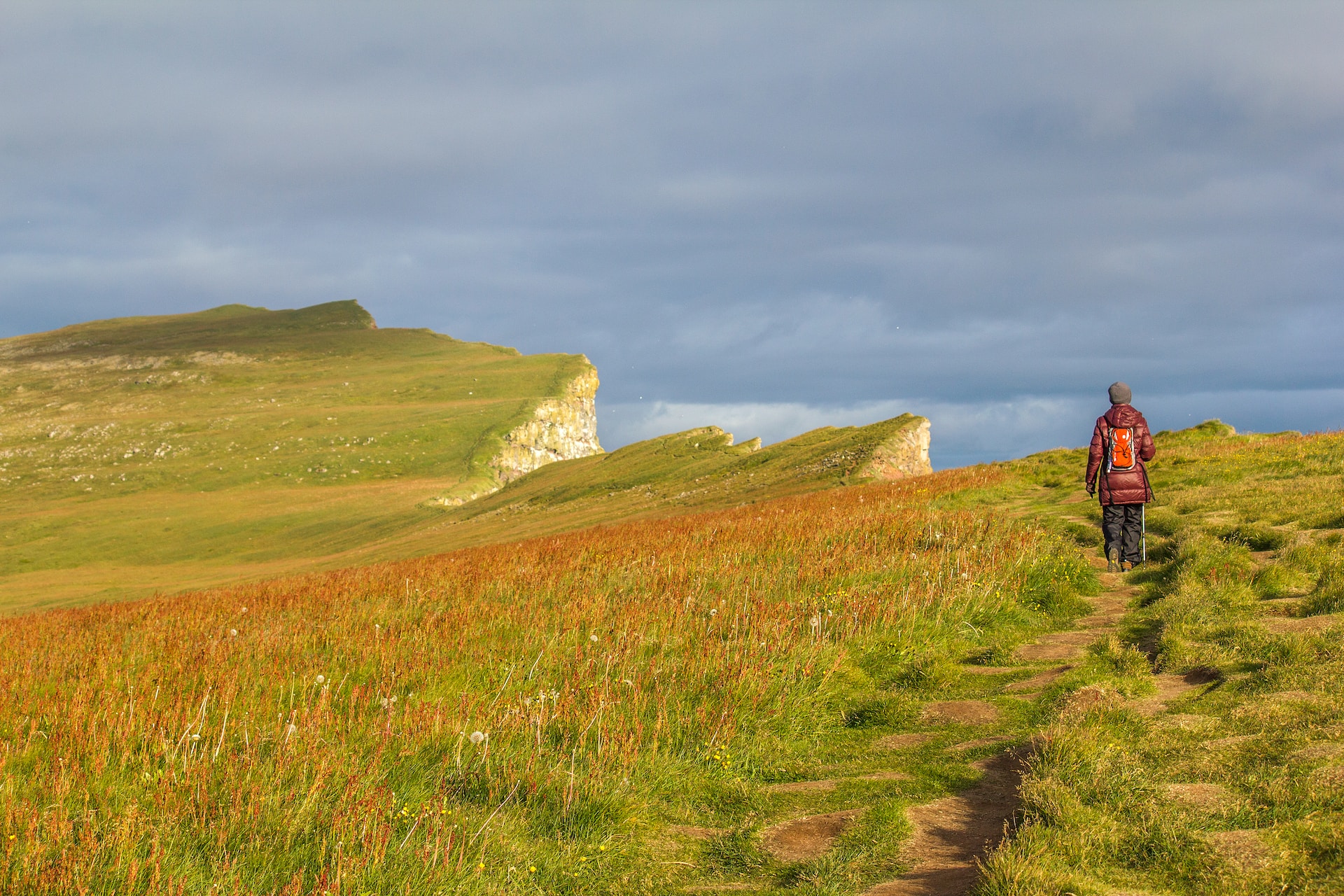
The Westfjords, by contrast, represent Iceland’s most remote and rugged region — a massive, sparsely populated area characterized by craggy cliffed fjords, towering bird cliffs, red sand beaches, and some of Iceland’s most dramatic waterfalls. Accessible only during summer months (June to August) when gravel roads are open and conditions stable, the Westfjords demand more time, tougher driving, and greater commitment. This is Iceland’s ultimate off-the-beaten-path destination, where isolation and raw natural beauty create unforgettable experiences for those willing to venture beyond the Ring Road.
A standard 2WD model can comfortably manage the Snæfellsnes loop from June to August, provided you drive cautiously on the gravel segments of northern Route 54.
Mandatory for the Westfjords in all seasons, and essential for Snæfellsnes from October to April. Negotiating steep gravel passes (Road 614 to Rauðasandur), remote coastal corridors, and gravel switchbacks demands a high-clearance, capable 4WD vehicle. 2WD models are not recommended for the Westfjords under any circumstances.
The Snæfellsnes Peninsula earns its nickname “Iceland in Miniature” by concentrating nearly every iconic Icelandic landscape type into one 90-kilometer (56-mile) stretch of West Iceland coastline. Located between the Reykjanes Peninsula (near Reykjavík) and the Westfjords to the north, Snæfellsnes offers an easily navigable loop that showcases glaciers, volcanoes, lava fields, coastal cliffs, charming villages, and diverse wildlife.
Snæfellsjökull National Park, at the peninsula’s western tip, centers around the Snæfellsjökull glacier — a 1,446-meter (4,744-foot) glacier-capped stratovolcano visible from Reykjavík on clear days. This mystical peak famously inspired Jules Verne’s “Journey to the Center of the Earth” and is considered one of Iceland’s most powerful energy sites. The last eruption occurred around 1,800 years ago, but the volcano remains classified as active.
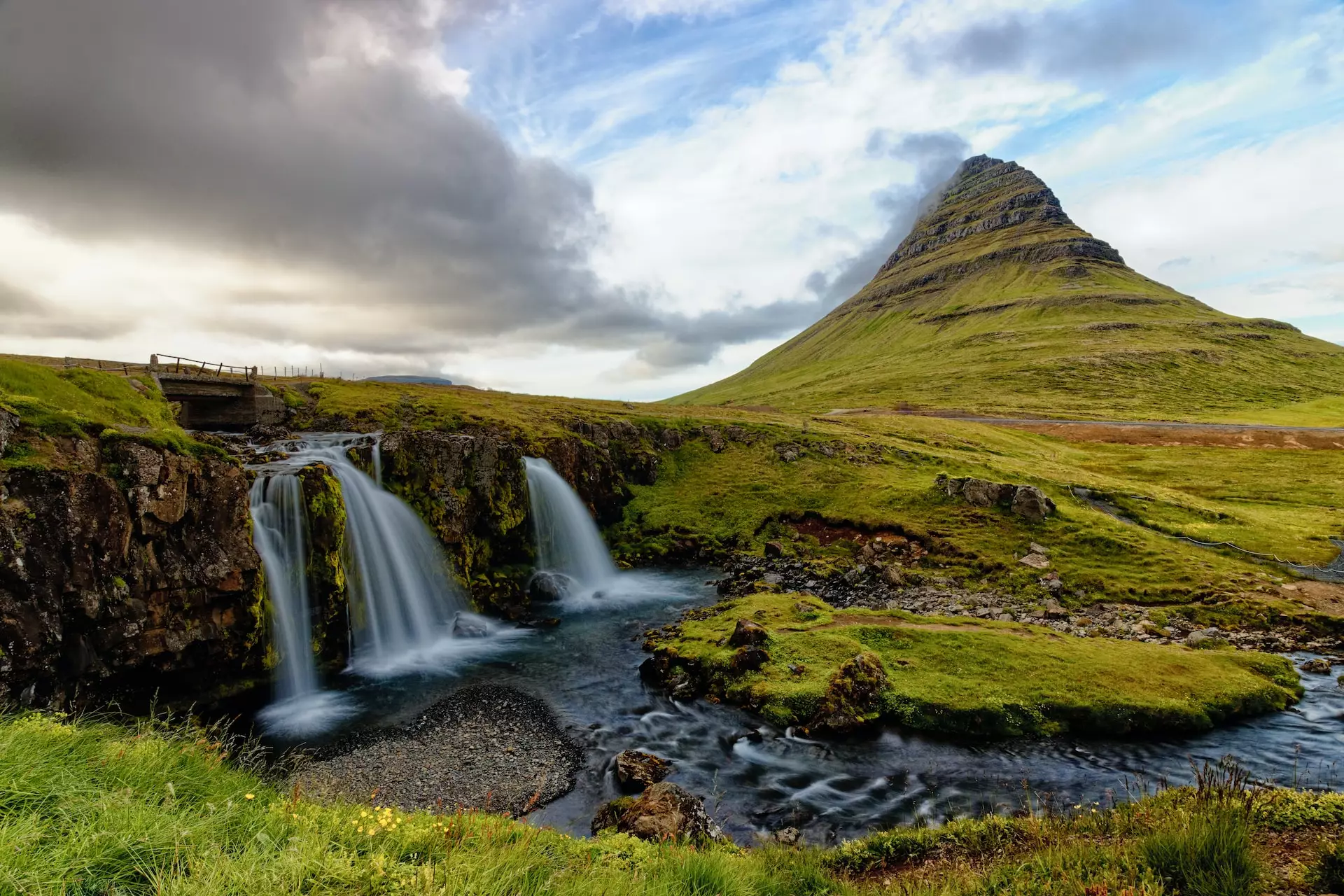
Kirkjufell Mountain (“Church Mountain”), rising 463 meters (1,519 feet) near the fishing town of Grundarfjörður on Snæfellsnes’ northern coast, is arguably Iceland’s most photographed mountain. Its distinctive pyramid shape, especially when paired with the cascading Kirkjufellsfoss waterfall in the foreground, creates one of Iceland’s most iconic compositions — featured prominently in Game of Thrones. The mountain is located approximately 2.5 hours’ drive from Reykjavík via Route 1 to Borgarnes, then Route 54 west.
Stykkishólmur, the largest town on Snæfellsnes with around 1,100 residents, is a charming fishing village known for its colorful harbor, vibrant wooden houses, and excellent seafood restaurants. The town serves as a departure point for Breiðafjörður ferry tours to the Westfjords and offers cultural attractions including the Library of Water art installation and the Norwegian House museum.
Additional Snæfellsnes highlights include:
Driving the Snæfellsnes Peninsula:
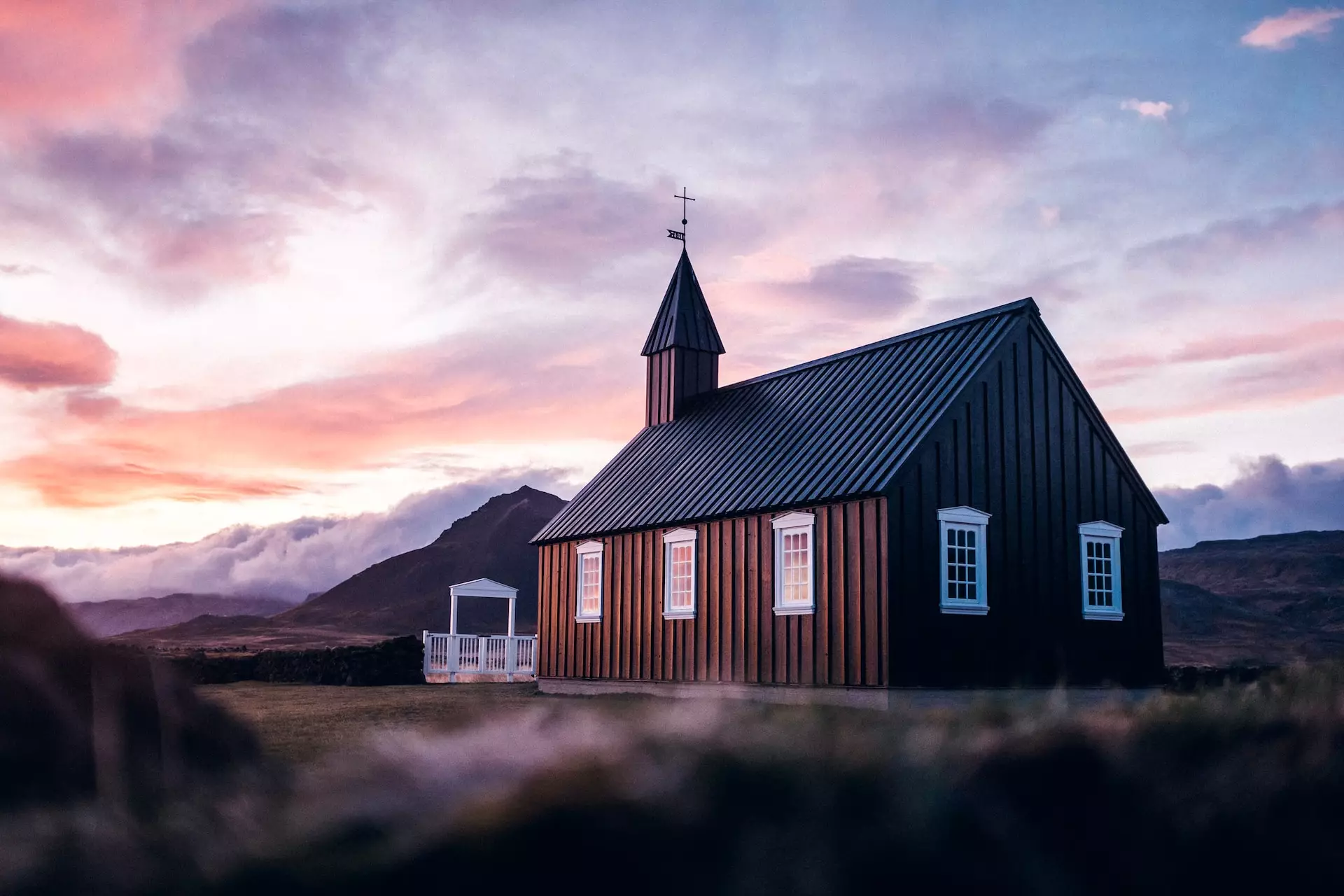
Iceland’s iconic black-stained wooden church, minimalist architecture set against lava fields. Reached smoothly via the paved arteries of southern Route 54 with free on-site parking.
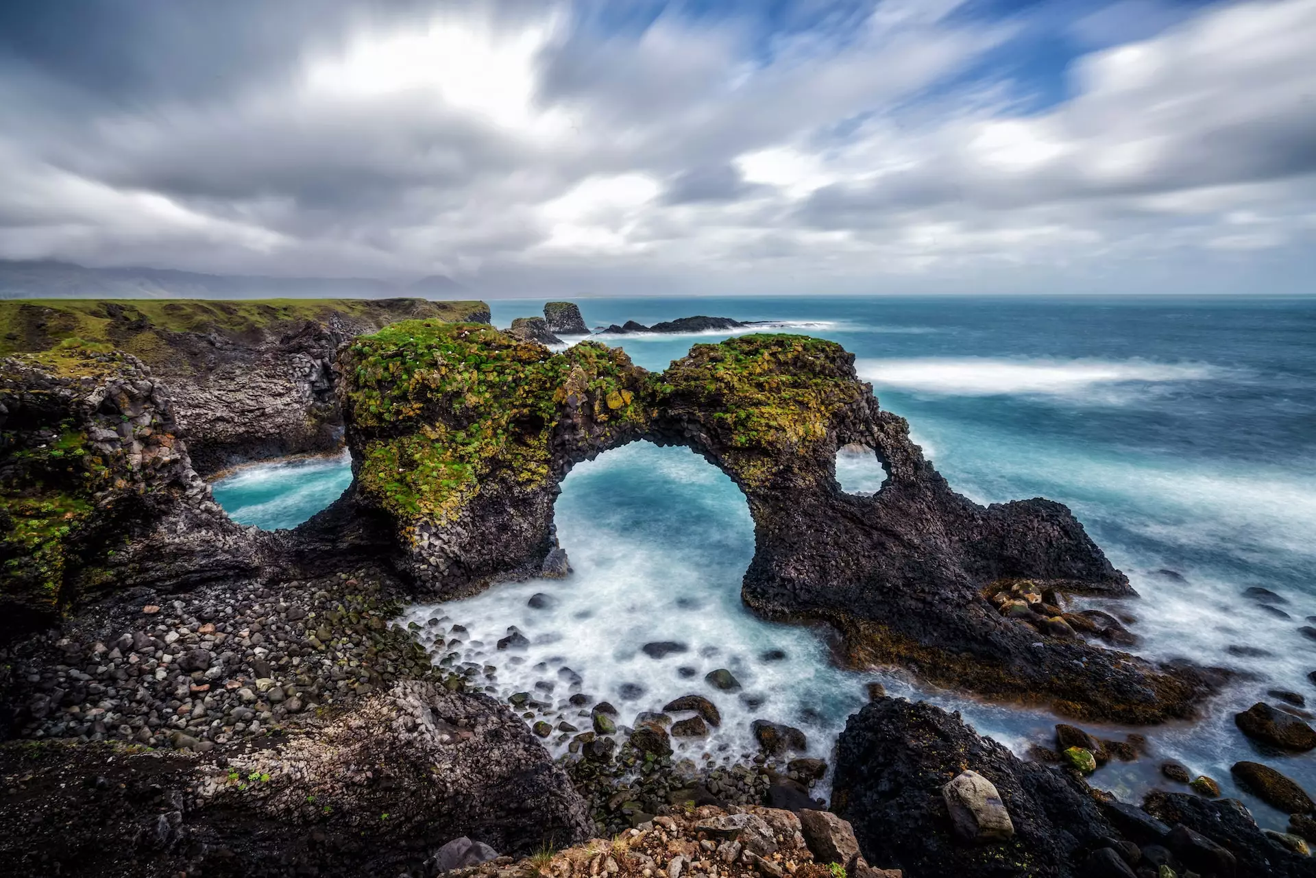
Stroll along the spectacular clifftop trails connecting Arnarstapi and Hellnar. Features exceptional columnar basalt arcs and seabird colonies with free parking access.
Iceland’s most photographed landmark paired with Kirkjufellsfoss. Reached via northern Route 54; features a dedicated digital-pay parking infrastructure (ISK 1,000).
The Westfjords represent Iceland’s final frontier — a vast, sparsely populated region of dramatic fjords, towering bird cliffs, and untouched wilderness accessible only to those willing to navigate challenging gravel roads and commit significant time. This is Iceland’s most remote and least-visited region, offering raw natural beauty and complete isolation from tourist crowds.
Best time to visit: June to August only — roads to major attractions like Rauðasandur Beach and Látrabjarg Cliffs are closed outside summer months due to snow and impassable conditions. Even in summer, expect rough gravel roads, slow driving speeds, and weather that can change rapidly.
Dynjandi Waterfall is widely considered the “Jewel of the Westfjords” and one of Iceland’s most magnificent waterfalls. The waterfall cascades 100 meters (328 feet) down a mountainside in a series of seven tiers, with the top cascade widening dramatically from 30 meters to 60 meters as it fans out in a bridal-veil formation. The hike from the parking area to the top of Dynjandi takes approximately 30-45 minutes, passing all seven cascades. Allow 2-3 hours total for the visit, including drive time from Flókalundur in the south.
Rauðasandur Beach (“Red Sand Beach”) is one of Iceland’s most striking and remote beaches, featuring unique reddish-gold sand (rare in Iceland) stretching for 10 kilometers along the southern Westfjords coast. The beach is accessible only via gravel Road 614 from Route 612, and the final approach involves a steep, winding descent — 4WD strongly recommended. The beach is accessible only June-August when the access road is open. Allow at least 1 hour for the visit.
Látrabjarg Cliffs form Europe’s westernmost point and rise 440 meters (1,444 feet) above the Atlantic Ocean, stretching 14 kilometers (9 miles) along the Westfjords’ western edge. These dramatic sea cliffs host millions of nesting seabirds from June to mid-August, including puffins, guillemots, razorbills, and fulmars — making Látrabjarg one of Iceland’s premier birdwatching destinations. The best time to see puffins is June to mid-August, with peak viewing in early morning or late afternoon/evening when they return from fishing.
Ísafjörður, the Westfjords’ largest town (population ~2,600), serves as the region’s main hub with accommodations, restaurants, museums, and tour operators. The town sits at the end of a dramatic fjord surrounded by steep mountains and provides a comfortable base for exploring the surrounding wilderness.
Driving the Westfjords:
The “Jewel of the Westfjords”—a thunderous, fan-shaped cascade dropping 100 meters. Reached via Route 60, featuring an active digital-pay parking framework (ISK 1,040).
Europe’s westernmost point, rising 440 meters along a 14 km cliff line. Home to millions of nesting puffins from June to mid-August. Reached via narrow gravel mountain roads (Road 612).
The cultural and commercial capital of the remote frontier, surrounded by towering fjord mountains. Offers comprehensive resupply services and houses our local Ísafjörður Airport (IFJ) branch.
Reykjavík, Iceland’s vibrant capital with a population of approximately 135,000 residents (about 240,000 in the greater capital region), is where most travelers begin their Ring Road adventure. Although Reykjavík itself is not officially part of Route 1 (the Ring Road), which stretches 1,322 kilometers (821 miles) around Iceland’s coastline, the capital serves as the natural starting and ending point for most Ring Road trips.
Most international visitors arrive at Keflavík International Airport (KEF), located 50 kilometers (31 miles) southwest of Reykjavík — approximately 40-50 minutes’ drive via Route 41 (Reykjanesbraut). From KEF Airport, travelers typically pick up rental cars and either explore Reykjavík first or head directly to Ring Road attractions, with the Golden Circle (90 minutes from KEF) or South Coast waterfalls (1.5-2 hours from Reykjavík) being common first stops.
The Ring Road can be driven in either direction — clockwise (heading north and west first) or counterclockwise (heading south and east first) — though most travelers drive counterclockwise as this places Iceland’s most famous attractions (Golden Circle, South Coast waterfalls, Jökulsárlón Glacier Lagoon) at the beginning of the trip when energy and enthusiasm are highest.
Route 1 (Þjóðvegur 1 in Icelandic), officially known as the Ring Road, is a 1,322-kilometer (821-mile) highway that circles Iceland’s entire coastline, connecting all major regions except the Westfjords and Snæfellsnes Peninsula. Completed in 1974 to connect Iceland’s remote corners, the route is now mostly smooth, paved tarmac accessible with any regular 2WD rental car — no 4×4 required for the Ring Road itself.
Driving time: The full loop takes approximately 17 hours of non-stop driving under ideal conditions, but this would leave zero time for sightseeing or stops. Most travelers allocate 7-10 days minimum for a Ring Road trip to properly explore attractions, with 10-14 days being ideal for a more relaxed pace.
Average daily driving distance: On a 7-day trip, expect to drive approximately 190 kilometers (118 miles) per day, allowing time for sightseeing, meals, and accommodation. On a more relaxed 10-day itinerary, daily drives average around 130-140 kilometers.
Direction recommendations:
Neither route is wrong — choose based on your preferences, weather forecasts, and whether you want to “save the best for last” or enjoy highlights early.
Reykjavík is the vibrant capital of Iceland and a must-see on any itinerary — serving as both a destination and a gateway to Iceland’s natural wonders. This bustling city offers a mix of culture, history, and modern attractions that make it worth dedicating 1-2 days before or after your Ring Road trip.
Explore the charming streets filled with colorful buildings and unique architecture, from the striking modernist Hallgrímskirkja church (Reykjavík’s most iconic landmark, offering panoramic city views from its tower) to the futuristic Harpa Concert Hall along the Old Harbour. Reykjavík is known for its thriving arts scene — museums, galleries, and vibrant street art dot the cityscape.
Local cuisine is another highlight, from traditional Icelandic fare to international delights. Sample fresh seafood, Icelandic lamb, and the local yogurt-like product skyr at restaurants throughout the city. The Old Harbour area offers excellent seafood restaurants and whale-watching tour departures.
Must-do activities in Reykjavík:
Day trips from Reykjavík:
Reykjavík is also a gateway to surrounding natural wonders, with the Golden Circle (a 230-kilometer loop featuring Þingvellir, Geysir, and Gullfoss) being the most popular day trip — easily completed in 6-8 hours and accessible from the city. The Blue Lagoon geothermal spa is just 20 kilometers (15-20 minutes) from KEF Airport and makes an excellent stop on arrival or departure day.
This makes Reykjavík both a destination in itself and the ideal starting point for Ring Road exploration.
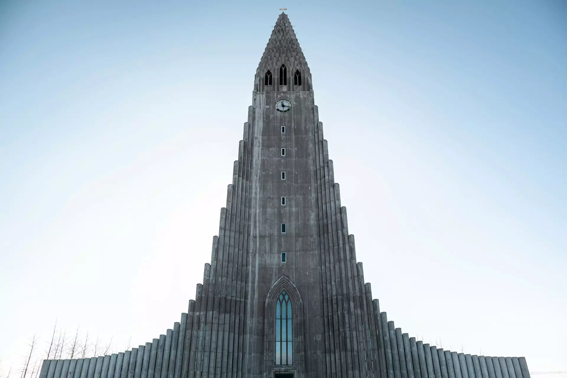
Iceland’s architectural crown jewel, standing 74.5 meters tall with a design inspired by basalt columns. Subject to downtown city parking zone regulations.
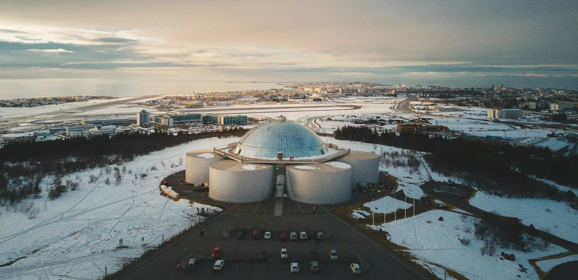
Perched on Öskjuhlíð hill, this futuristic dome features a real indoor ice cave and a 360° observation deck. Offers extensive, easy-access parking for rental vehicles.
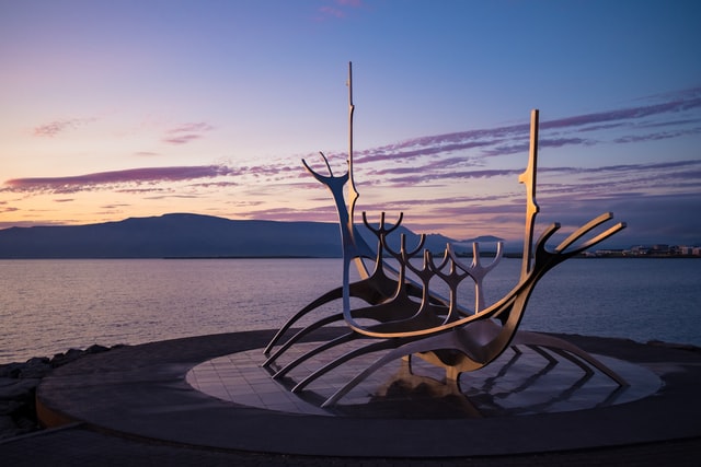
A magnificent stainless steel dreamboat sculpture located on the scenic waterfront, symbolizing progress and freedom. Easily reached via the main capital coastal routes.
Jökulsárlón Glacier Lagoon is widely considered the ultimate scenic jewel along Iceland’s Ring Road (Route 1), located on the South Coast approximately 377 km from Reykjavík. The lagoon features massive blue icebergs calving from the Breiðamerkurjökull glacier, drifting past native harbor seals toward the open ocean.
Directly across Route 1 lies Diamond Beach, where these icebergs wash ashore onto black volcanic sand, creating an incredible high-contrast landscape. The entire South Coast stretch from Selfoss to Höfn (~460 km) offers Iceland’s most concentrated collection of dramatic scenery, including Seljalandsfoss, Skógafoss, and Reynisfjara Black Sand Beach.
Yes, absolutely. From September through April, several key Ring Road waypoints in North Iceland offer prime parameters for aurora viewing due to lower light pollution.
Goðafoss Waterfall is the most accessible aurora photography spot, located right off Route 1 between Akureyri and Mývatn. Its wide, semi-circular horseshoe cascade provides a dramatic, reflective foreground for the lights. The Lake Mývatn geothermal area is another excellent base, where you can even experience the Northern Lights while soaking in the open-air waters of the Mývatn Nature Baths.
No, the Golden Circle is not part of the Ring Road. It is a separate 230-kilometer (142-mile) tourist loop located immediately east of the capital. It showcases three iconic landmarks: Þingvellir National Park, the Geysir Geothermal Area, and Gullfoss Waterfall.
Because both routes originate in the Reykjavík sector, most Ring Road travelers tackle the Golden Circle as a half-day detour at the absolute start or end of their cross-country itinerary. The entire Golden Circle loop is paved and completely accessible with a standard 2WD rental vehicle during summer.
Standard sightseeing stops usually require 1.5 to 2 hours to comfortably admire the floating icebergs at the lagoon and explore Diamond Beach across the highway.
If you plan to secure a slot on a guided amphibian or zodiac boat tour, you should allocate at least half a day (3–4 hours) on-site. Because the single-way drive from Reykjavík takes roughly 5 hours, Hertz local experts strongly recommend planning an overnight stay near Höfn or Vík rather than attempting a rushed, grueling round-trip in a single day.
Yes, during the summer months (May–September). The entire 1,322 km Ring Road (Route 1) artery is fully paved, smooth tarmac. Major natural milestones like Jökulsárlón, Seljalandsfoss, Skógafoss, and Goðafoss sit directly off the highway and can be reached using standard Economy or Compact vehicles without off-road driving.
However, an upgrade to a 4WD SUV remains highly recommended if you plan to execute rural detours onto unpaved gravel tracks (such as northern sections of the Snæfellsnes Peninsula). From November to March, a 4WD vehicle is essential for all itineraries to ensure safe handling on seasonal ice, slush, and heavy snow pack.
Reynisfjara is entirely safe only if you follow posted local regulations and stay well away from the waterline. It is classified as one of Iceland’s most hazardous coastal environments due to sudden, high-velocity sneaker waves that can pull unsuspecting visitors into freezing, high-current water columns.
Yes, via a straightforward highway detour. When traveling the Ring Road, you can depart Route 1 at the commercial junction of Borgarnes and transition onto Route 54 heading west. The drive from Reykjavík to the peninsula core takes approximately 2 hours.
Completing the full coastal loop around Snæfellsnes (via Route 54 and Route 574) requires at least 3 hours of non-stop driving. It is widely referred to as “Iceland in Miniature” due to its dense concentration of lava fields, black churches, and glacier peaks. Note that segments of Route 54 on the northern side approaching Stykkishólmur remain rough, unpaved gravel paths.
The Golden Circle and prime South Coast lifelines offer the most robust infrastructure for families traveling with young children, featuring paved parking lots, protective guard railings, and brief walking thresholds:
Local Fleet Advice: Remote locations like Stuðlagil Canyon (demanding steep, slippery descents) or interior highland F-roads are highly unsuited for families traveling with small children or infants.
Iceland’s Ring Road delivers one of the world’s most spectacular road trips — where every turn reveals glaciers, waterfalls, volcanic landscapes, and coastal wonders that few places on Earth can match. From the thundering power of Dettifoss to the serene beauty of Jökulsárlón’s floating icebergs, from the black sand beaches of Reynisfjara to the geothermal wonders of Lake Mývatn, this route showcases Iceland’s raw natural beauty at its finest.
Hertz Iceland has been supporting Ring Road travelers since 1971 — making us Iceland’s longest-established car rental provider and the only operator with an in-terminal counter in the arrival hall at Keflavík International Airport. With 11 locations across Iceland, a locally based Icelandic team, and a fleet no more than two years old, we’re built to get you to every scenic stop on this list in comfort and confidence. Whether you’re embarking on a quick 7-day loop or a comprehensive 14-day exploration, we provide the reliable vehicles, local expertise, and nationwide support you need to make your Ring Road adventure unforgettable.
Start planning your journey today, and discover why Iceland’s Ring Road remains one of the world’s most celebrated road trips — where nature’s grandest spectacles await around every corner.

LFAI | Group: I7 (LFAI)

PFAN | Group: G6 (PFAN)

RGAC | Group: I2 (RGAC)

UGDC | Group: V1 (UGDC)

GFAR | Group: H1 (GFAR)

SFAN | Group: O2 (SFAN)

Sign up for big savings!